Hike This Aroostook County Volcano For Massive Fall Foliage Views
These hikes feature Big County views, perfect for leaf-peeping.
Looking for massive views in the Crown of Maine? We have two for you that are well worth the drive. Whether you take Route 11, or Route 1 to 163, it's a gorgeous drive. Route 11 will soon be ablaze with fall colors, which you'll see in all its glory if you drive to the bonus hike we've added to give you a full day of hiking.
Haystack Mountain
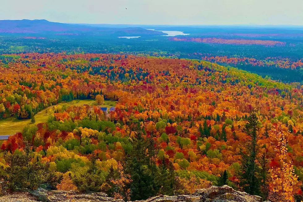
Haystack Mountain in Castle Hill is a stellar fall hike. The photo above shows just how impressive the view is atop its mostly bald summit, giving you a nearly 360-degree view of farmland, distant ponds, and an endless sea of trees. The hike is only a 0.5-mile trek to the top, with about 180 feet in elevation gain from the parking area. However, you'll work for those views, as the trail is steep and requires some rock scrambling near the summit. After all, you're hiking an ancient volcano.
Haystack was prone to violent eruptions for about 50,000 years. The stratovolcano is believed to have formed underwater until it broke sea level and became a volcanic island. Imagine that, everything you see from the summit was under the Matapedia Sea, 430 million years ago. One hundred thousand years ago, Haystack was 1 1/2-to-2 miles under a massive continental-sized glacier. The ice sheet was thick enough to cover Mt. Katahdin, and Mt. Washington, in New Hampshire. All of this information is documented on the trailhead kiosk.
How To Get There:
These directions will take you to the parking lot. The directions we programmed will take you to Haystack via Route 11. It's a beautiful road but watch for deer and BIG moose. The trailhead is marked by a roadside sign on the left-hand side of the road, about 10 minutes outside Ashland.
The Hike:
- The trail is marked with blue blazes and well-traveled.
- The trail begins on relatively flat ground by the trailhead kiosk.
- As previously mentioned, the hike is only half a mile. However, the trail is steep and requires rock scrambling near the summit.
- Take your time going down the trail, as loose rocks create tricky footing.
Additional Info:
- There's no fee to enjoy the trail system.
- The parking area features a covered picnic table.
- Dogs (leashed) are welcome on the trail.
Wolfe In The Wild Pro Tips:
- I want to reiterate, the trail is steep with loose rocks. The footing is tricky in spots. Near the summit, there's a bit of rock scrambling to follow the trail.
- Take your time. I consider myself a seasoned hiker, but I took many breaks going up. Going full gas up this trail will leave you dead-legged for the decent, the trickiest part of this hike. This is just my suggestion, you know your limits best.
- Bring binoculars.
- I opted to wear blaze orange when I visited, as it was the beginning of moose hunting season.
BONUS HIKE: Hedgehog Mountain
After you hit Haystack, about 40 minutes away is our next suggested hike. This hike features a summit view of the St. John Valley that's endless. It also features glimpses of Maine forestry history, with an abandoned Forest Service cabin.
Hedgehog Mountain near Winterville Plantation is a .7 mile hike up yet another steep trail. The trail is well-traveled, but not marked. Near the trailhead, you'll see the remnants of a forest service cabin. At the summit, you can see the anchor points for an old fire tower, which was torn down in 1978.
The summit is a small vantage point that features views of the North Maine Woods, Portage Lake, St. Froid Lake, and Fish River connecting the two. The photos in this portion of the article were taken in May, so just imagine what that view would look like ablaze with fall colors.
How To Get There:
These directions will take you from the parking lot of Haystack to the Hedgehog Mountain parking area, which is also a rest area. A landmark for reference is Soucy Hill. It's a MASSIVE hill featuring a double lane. Shortly after your ascent, you'll reach the rest area, on the left-hand side of the road.
The Hike:
- As we mentioned before, the trail is not marked. However, it has been well-traveled over the years, so staying on the trail isn't difficult.
- To find the trailhead, walk from the parking area to the far-side treeline. A blue sign with an arrow points to the trailhead.
- Another sign you're on the right track is the abandoned forest service cabin and dilapidated hunting cabin that the trail snakes between.
- After the .7 mile hike, you'll reach the small summit, with big views.
Additional Info:
- There's no fee to enjoy the trail system.
- The rest area features covered picnic tables, grills, and a bathroom.
- The summit features a picnic table.
- Dogs (leashed) are welcome on the trail.
Wolfe In The Wild Pro Tips:
- This trail is steep, and for the most part unmaintained. Near the top Big County storms have eroded the trail. Some sections of the trail are a little tricky, with big steps up and down.
- That being said, take your time on the trail and watch your footing. You're a long way from help and sustained cell service.
- This hike explodes in popularity during foliage season. It's not uncommon to see the parking area full. If you park on the nearby logging road, owned by Irving Woods, be respectful with your parking job. Not only is it an active logging operation, but popular with moose hunters as well. Really, it's best to not park there.
- The summit is small. So if you see the parking area full, it may be a good idea to continue up Route 11 and see the sights. The road continues north to Fort Kent. Return when it's less populated. It's hard to take in the views with people crowding the overlook.
- As you may have gathered, the area is a big-time moose hunting territory, so wear blaze orange if you visit during any hunting seasons.
- Don't confuse this Hedgehog Mountain for the one by the same name near Freeport. Online this hike is lesser written of, which is why we packed this article with handy know before you go info.
- Bring binoculars.
- Stay on the trail. There are miles and miles of woods to get seriously lost in.
- The bugs are unreal throughout the summer. BRING BUG DOPE.
Getting Home:
First, if you're vehicle is low on fuel, you can head north on Route 11 to Eagle Lake. There are two gas stations in town and grocery stores for snacks and beverages. You can also refuel in Portage Lake or Ashland. The simple way home from Hedgehog is to head southward on Route 11. You can follow Route 11 down to I-95 in Sherman. If you want GPS guidance, here's how to get back to the Bangor area.
Keep these trail systems beautiful and carry out ALL trash and waste.

10 Ways Aroostook County Is Unlike Anywhere Else In Maine
Pigeon Hill Preserve Has Ocean Views, Abandoned Silver Mine
More From 94.9 WHOM